
Places to Birdwatch in the BCAS Area
The Black Canyon Audubon Society area covers many counties in Southwestern Colorado with numerous wonderful places to birdwatch. We would like to share that information with our members and visitors to our area. Keep your eyes on this space as we add places where we enjoy birdwatching in our area!
Lugares para la Observación de Aves en el Área BCAS
El área de la Black Canyon Audubon Society cubre muchos condados del suroeste de Colorado con numerosos lugares maravillosos para observar aves. Nos gustaría compartir esa información con nuestros miembros y visitantes de nuestra área. ¡Mantén tus ojos en este espacio mientras agregamos lugares donde disfrutamos de la observación de aves en nuestra área!
Delta County
Crane Viewing Areas (stars) north and west of Delta
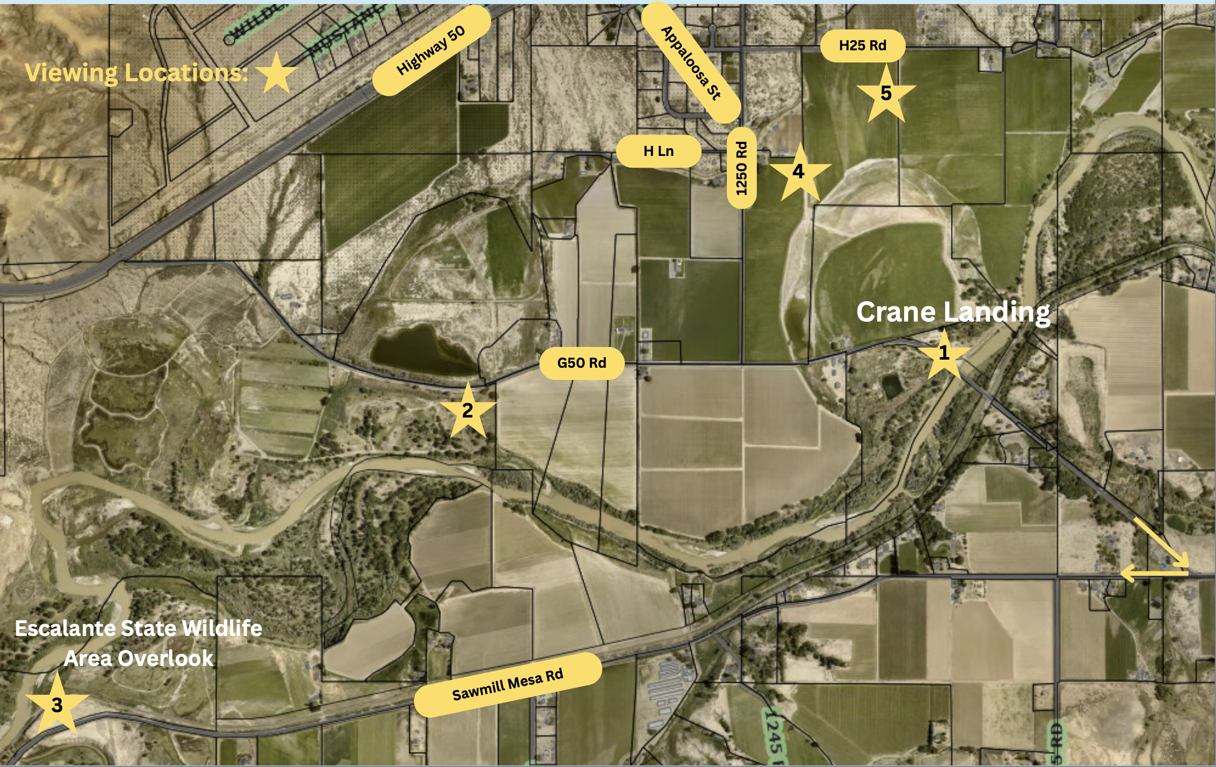
Confluence Park, Delta
Managed by: Delta County
Location: City of Delta along the Gunnison and Uncompahgre Rivers
Ubicación: Ciudad de Delta a lo largo de los ríos Gunnison y Uncompahgre
Directions: From Delta drive north on US 50 past City Market. Turn left at the light on Confluence Drive and continue to first traffic light. Turn right onto N. Palmer St. and take the first left onto Gunnison River Dr. You will come to a ‘T’ at Kellogg St. and can turn either direction to find parking. To the right, you can access the Gunnison River and hiking trails. To the left, you can park at various locations along the reservoir and access hiking trails at the end of the road on the west side of the reservoir.
Indicaciones: Desde Delta, conduzca hacia el norte por la US 50 y pase City Market. Gire a la izquierda en el semáforo de Confluence Drive y continúe hasta el primer semáforo. Gire a la derecha en N. Palmer St. y tome la primera a la izquierda en Gunnison River Dr. Llegará a una "T" en Kellogg St. y podrá girar en cualquier dirección para encontrar estacionamiento. A la derecha, puede acceder al río Gunnison y a las rutas de senderismo. A la izquierda, puedes aparcar en varios lugares a lo largo del embalse y acceder a rutas de senderismo al final de la carretera en el lado oeste del embalse.
Accessibility: All access streets are paved. Some parking areas are paved, some are gravel. All paths are gravel or dirt. There are ~5 miles of interconnecting paths through various habitat types.
Accesibilidad: Todas las calles de acceso están pavimentadas. Algunas zonas de aparcamiento están pavimentadas y otras son de grava. Todos los caminos son de grava o tierra. Hay ~5 millas de caminos interconectados a través de varios tipos de hábitat.
Habitat type: Woodland, meadow, riparian, and wetland.
Tipo de hábitat: bosque, pradera, ribereño y humedal.
Birds you might see: A wide variety including herons, ducks, geese, songbirds, raptors, quail, and owls; 203 species of birds have been observed. During late fall and winter, a large number of geese and ducks arrive, including Snow, Ross’, Cackling, and, occasionally, White-fronted in the company of thousands of Canada geese. Barrow’s goldeneye are on the river during the winter and sometimes a few make it onto the reservoir along with a wide number of other waterfowl. Sandhill cranes are often seen in migration, as do Franklin’s and Bonaparte’s gulls in the spring. A few Clark’s grebes can also be expected mixing with the Western grebes in the summer months.
Aves que podría ver: una amplia variedad que incluye garzas, patos, gansos, pájaros cantores, aves rapaces, codornices y búhos; Se han observado 203 especies de aves. A finales del otoño y el invierno, llega una gran cantidad de gansos y patos, incluidos Snow, Ross, Cackling y, ocasionalmente, White-frenti, en compañía de miles de gansos canadienses. El ojo dorado de Barrow está en el río durante el invierno y, a veces, algunos llegan al embalse junto con una gran cantidad de otras aves acuáticas. Las grullas canadienses se ven a menudo durante la migración, al igual que las gaviotas de Franklin y Bonaparte en la primavera. También se puede esperar que algunos somormujos se mezclen con los somormujos occidentales en los meses de verano.
Best time of year: Visit year around to see different types of birds in different seasons.
Mejor época del año: visite durante todo el año para ver diferentes tipos de aves en diferentes estaciones.
More Information: deltacountycolorado.com. There are also descriptions at deltacountyindependent.com, traveladvisor.com, and deltacountyliving.com.

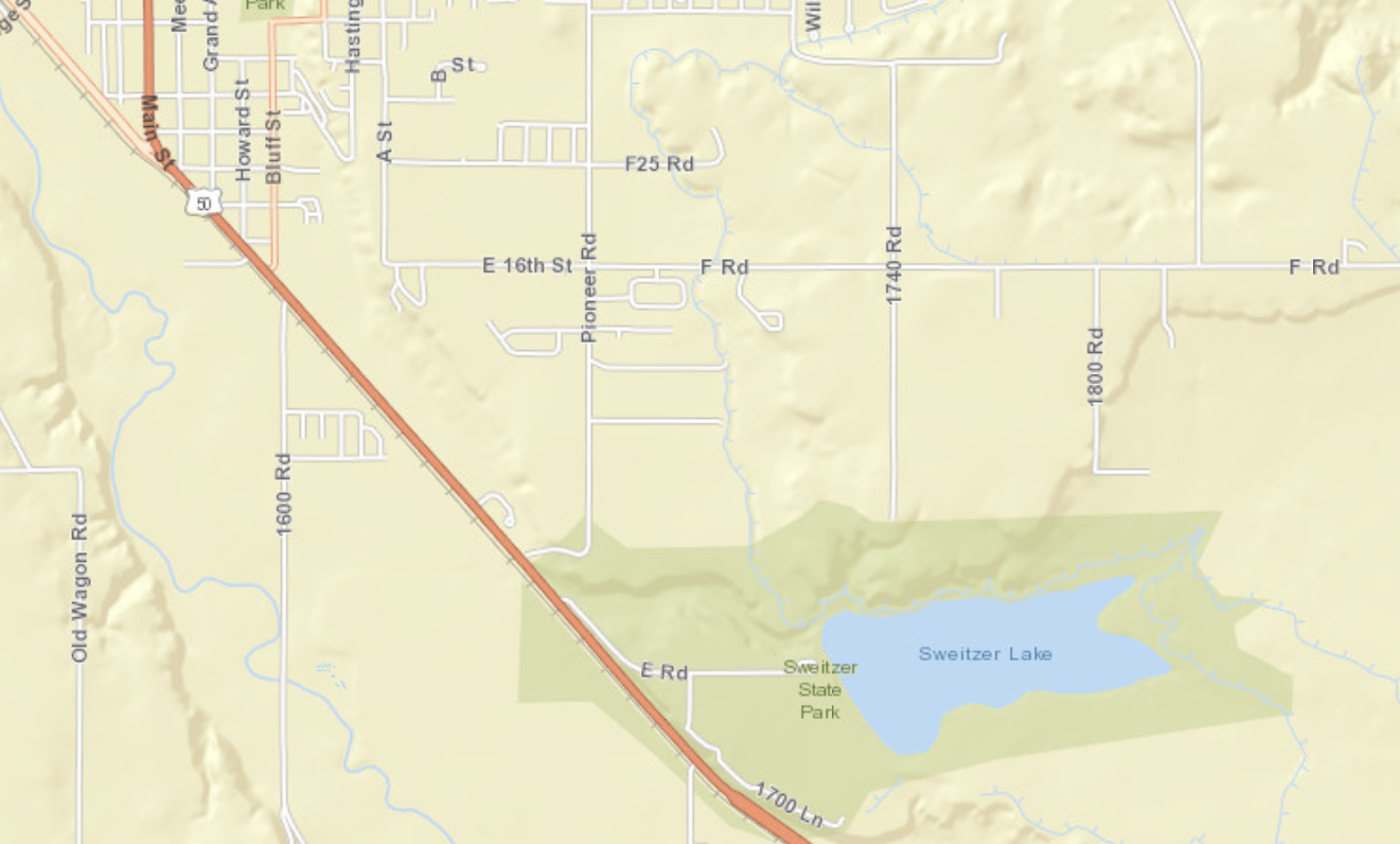
Sweitzer Lake State Park, Delta
Management: Colorado Parks and Wildlife
Directions: From Montrose, travel 19 miles north on US Highway 50 towards Delta. As you approach Delta, watch for a large brown sign indicating the entrance to the park. Turn right where indicated onto Road E. This will take you into the park. From Delta, drive south on US Highway 50 about one mile. Watch for a large brown sign indicating the entrance to the park. Turn left where indicated onto Road E. This will take you into the park.
Indicaciones: Desde Montrose, viaje 19 millas al norte por la autopista US 50 hacia Delta. Al acercarse a Delta, esté atento a un gran cartel marrón que indica la entrada al parque. Gire a la derecha donde se indica hacia Road E. Esto lo llevará al parque. Desde Delta, conduzca hacia el sur por la autopista US 50 aproximadamente una milla. Esté atento a un gran cartel marrón que indica la entrada al parque. Gire a la izquierda donde se indica hacia la carretera E. Esto le llevará al parque.
Accessibility: An entrance fee is collected year round. Either pay at entrance station or purchase or possess a current Colorado State Parks Pass. The main parking lot is paved and public toilets are available. Follow the road that skirts around the south side of the lake. This road is not paved. Road is inaccessible when wet due to heavy clay soils.
Accesibilidad: Se cobra una tarifa de entrada durante todo el año. Pague en la estación de entrada o compre o posea un Pase de Parques Estatales de Colorado vigente. El estacionamiento principal está pavimentado y hay baños públicos disponibles. Siga la carretera que bordea el lado sur del lago. Este camino no está pavimentado. La carretera es inaccesible cuando está mojada debido a los suelos arcillosos pesados.
Habitat: Primarily salt desert scrub with large mature deciduous and coniferous trees at the entrance and near the parking lot and scattered brush throughout park. Wet alkali mud and riparian plants exist along the southern edge of the lake, including cattails and reeds.
Hábitat: Principalmente matorral desértico salado con grandes árboles maduros de hoja caduca y coníferas en la entrada y cerca del estacionamiento y matorral disperso por todo el parque. A lo largo del borde sur del lago existen lodo alcalino húmedo y plantas ribereñas, incluidas espadañas y juncos.
Birds you might see: Birds can be seen all year because the lake rarely freezes completely. Recreational use of the lake (reservoir) is quite heavy in the summer, which tends to scare off birds. Migratory song birds, however, can probably still be seen in the larger trees or along the boundary fence. During the rest of the year, a variety of shorebirds, ducks, wading birds, grebes, and gulls can be seen, as well as an occasional loon, pelican, and cormorant. Waterfowl hunting is allowed during the fall and winter on weekends, Wednesdays, and legal holidays. Birds of prey are always a possibility, including hawks, osprey eagles, accipiters, and falcons. Sweitzer Lake is an eBird hotspot with over 160 species recorded.
Aves que podrías ver: Se pueden ver aves durante todo el año porque el lago rara vez se congela por completo. El uso recreativo del lago (embalse) es bastante intenso en verano, lo que tiende a ahuyentar a las aves. Sin embargo, es probable que todavía se puedan ver pájaros cantores migratorios en los árboles más grandes o a lo largo de la valla delimitadora. Durante el resto del año se puede observar una variedad de aves playeras, patos, aves zancudas, zampullines y gaviotas, además de algún que otro colimbo, pelícano y cormorán. Se permite la caza de aves acuáticas durante el otoño y el invierno los fines de semana, miércoles y feriados legales. Las aves rapaces son siempre una posibilidad, incluidos halcones, águilas pescadoras, accipiteros y halcones. Sweitzer Lake es un punto de acceso de eBird con más de 160 especies registradas.
Best time of the year: Fall and spring are usually best to avoid summer recreational use and waterfowl hunting season, though it is well worth a stop any time of the year.
Mejor época del año: El otoño y la primavera suelen ser los mejores para evitar el uso recreativo de verano y la temporada de caza de aves acuáticas, aunque vale la pena detenerse en cualquier época del año.
Additional information: http://cpw.state.co.us/placestogo/parks/SweitzerLake
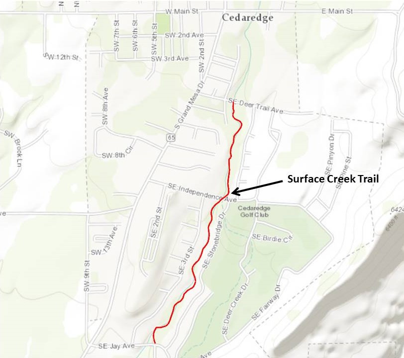
Surface Creek Walking Trail, Cedaredge, Delta County
Managed by: Town of Cedaredge
Location: Southeast side of the town of Cedaredge ~ ½ mile east of Hwy 65
Ubicación: Lado sureste de la ciudad de Cedaredge, ~ ½ milla al este de la Hwy 65
Directions: From Delta take Hwy 92 east to Hwy 65. Travel ~ 10 miles north to Cedaredge. There are three access points – SE Jay Ave., SE Independence Ave., and SE Deer Trail Ave.
Indicaciones: Desde Delta, tome la Hwy 92 este hasta la Hwy 65. Recorra aproximadamente 16 km al norte hasta Cedaredge. Hay tres puntos de acceso: SE Jay Ave., SE Independence Ave. y SE Deer Trail Ave.
Accessibility: All access points are paved roads. Limited roadside parking. The trail is an improved dirt trail just over a mile long one way.
Accesibilidad: Todos los accesos son carreteras pavimentadas. Estacionamiento limitado en la carretera. El sendero es de tierra en buen estado, de poco más de una milla de longitud, de un solo sentido.
Habitat type: Wooded riparian and rural residential along the eastern side of Surface Creek.
Tipo de hábitat: Ribereño boscoso y residencial rural a lo largo del lado este de Surface Creek.
Birds you might see: Mostly songbirds
Aves que podrías ver: Principalmente pájaros cantores
Best time of year: Probably best spring and summer, but good all year.
Mejor época del año: Probablemente mejor en primavera y verano, pero buena durante todo el año.
More information: n/a
Winter Raptors in Delta County
Aves rapaces invernales en el condado de Delta
Where: Public roads in the county between the towns of Paonia,Hotchkiss, and Crawford, and east of the North Fork of the Gunnison River
Dónde: Carreteras públicas del condado entre las localidades de Paonia, Hotchkiss y Crawford, y al este de la bifurcación norte del río Gunnison.
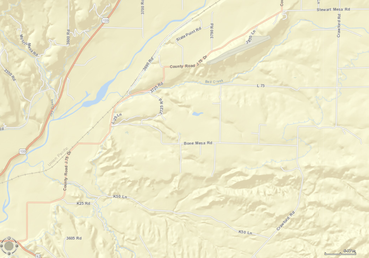
Directions: Northern Loop: From Hotchkiss, turn east on Highway 92. Cross the North Fork, proceed less than a mile, then turn north on Back River Road. The entire valley floor between the (roughly parallel) Back River Road and Crawford Road, from Hotchkiss to Paonia to Crawford, including the connector roads like Bone Mesa Road and L75 Road, offer great birding for raptors. Scan the fields and road sides for hawks. Look for eagles feeding on road kill, perched in cottonwoods and utility poles, and along the North Fork River.
Cómo llegar: Circuito Norte: Desde Hotchkiss, gire al este por la Highway 92. Cruce la bifurcación norte, continúe menos de 1,6 km y luego gire al norte por Back River Road. Todo el valle entre Back River Road (aproximadamente paralelas) y Crawford Road, desde Hotchkiss hasta Paonia y Crawford, incluyendo las carreteras de conexión como Bone Mesa Road y L75 Road, ofrece excelentes oportunidades para la observación de aves rapaces. Observe los campos y los bordes de las carreteras en busca de halcones. Observe águilas alimentándose de animales atropellados, posadas en álamos y postes de electricidad, y a lo largo del río North Fork.
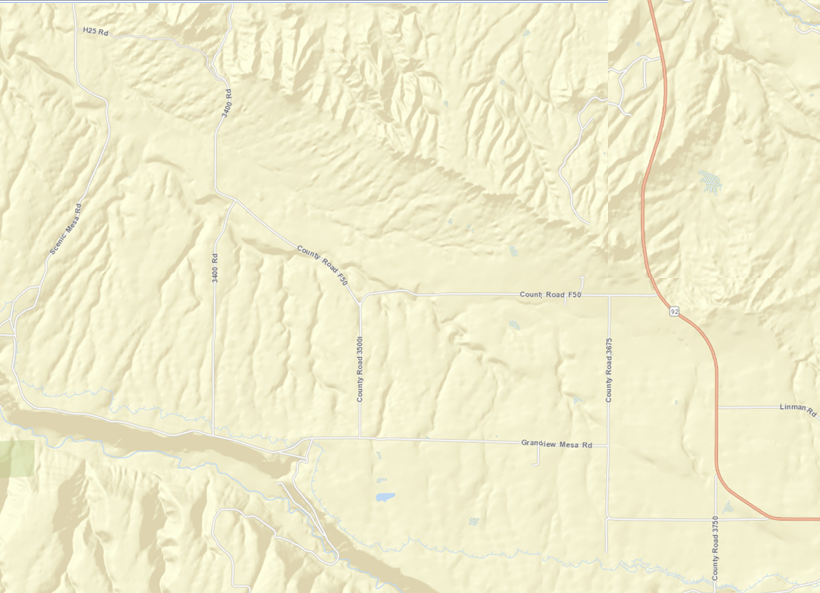
Directions, Southern Loop: From Hotchkiss, turn east on Highway 92. Cross the North Fork, and continue toward Crawford. After about five miles, turn right onto F50 Road (which eventually turns into 3400 Road). The road travels the lower portion of Grandview Mesa and eventually winds back down to the town of Hotchkiss. While traveling F50 Road, turn left (south) onto 3675 Rd, which leads to Grandview Mesa Road. Turn right (west) and follow this onto Scenic Mesa (the road becomes Scenic Mesa Road) and along the edge of Smith Fork Canyon, or turn north (right) onto 3500 Road or 3400 Road back to F50 Road. The mesas here, south of Hotchkiss and west of Highway 92, including Fruitland Mesa, Grandview Mesa, and Scenic Mesa, offer great winter raptor spotting. Watch for large great-horned owl nests in cottonwoods, and look for harriers hunting in low swales along water courses.
Indicaciones, Circuito Sur: Desde Hotchkiss, gire al este por la Highway 92. Cruce la bifurcación norte y continúe hacia Crawford. Después de unos ocho kilómetros, gire a la derecha en la carretera F50 (que finalmente se convierte en la carretera 3400). La carretera recorre la parte baja de Grandview Mesa y finalmente serpentea de regreso al pueblo de Hotchkiss. Mientras viaja por la carretera F50, gire a la izquierda (sur) en la carretera 3675, que conduce a la carretera Grandview Mesa. Gire a la derecha (oeste) y siga por esta hasta Scenic Mesa (la carretera se convierte en Scenic Mesa Road) y bordee el cañón Smith Fork, o gire al norte (derecha) en la carretera 3500 o 3400 de regreso a la carretera F50. Las mesetas aquí, al sur de Hotchkiss y al oeste de la Hwy 92, incluyendo Fruitland Mesa, Grandview Mesa y Scenic Mesa, ofrecen un excelente avistamiento de aves rapaces en invierno. Esté atento a los grandes nidos de búhos cornudos en los álamos y busque aguiluchos cazando en valles bajos a lo largo de los cursos de agua.
Accessibility: County roads are paved and gravel.
Accesibilidad: Las carreteras del condado están pavimentadas y son de grava.
Habitat type: Irrigated meadow, sagebrush, rabbitbrush, adobe badlands, pinon pine-Utah juniper woodlands, bisected by irrigation ditches, and washes.
Tipo de hábitat: Praderas de regadío, artemisa, matorral de conejo, tierras baldías de adobe, bosques de pino piñonero y enebro de Utah, atravesados por acequias y arroyos.
Birds you might see: Golden eagles, Bald eagles, red-tailed hawks, ferruginous hawks, sharp-shinned and Cooper's hawks, northern goshawks, prairie falcons, merlins, kestrels, great-horned owls, northern harriers, shrikes, and additional winter residents like bluebirds, pheasants, blackbirds, and ducks in the river.
Aves que se pueden observar: Águilas reales, águilas calvas, gavilanes colirrojos, aguiluchos ferruginosos, gavilanes de Cooper y de Cooper, azores, halcones de pradera, esmerejones, cernícalos, búhos cornudos, aguiluchos norteños, alcaudones y otras aves residentes invernales como azulejos azules, faisanes, mirlos y patos en el río.
Best time of year: December 1 to March 1.
Mejor época del año: Del 1 de diciembre al 1 de marzo.
More information: Be respectful of other travelers on all roads. Pull off the roadway as far as possible when stopping, so as not to impede other vehicles. When out of the vehicle stay within the road right-of-way. Do not cross onto private land.
Más información: Respete a los demás viajeros en todas las carreteras. Al detenerse, deténgase lo más lejos posible de la calzada para no obstaculizar a otros vehículos. Al salir del vehículo, manténgase dentro del derecho de paso. No cruce a terrenos privados.
North Loop Area
South Loop Area
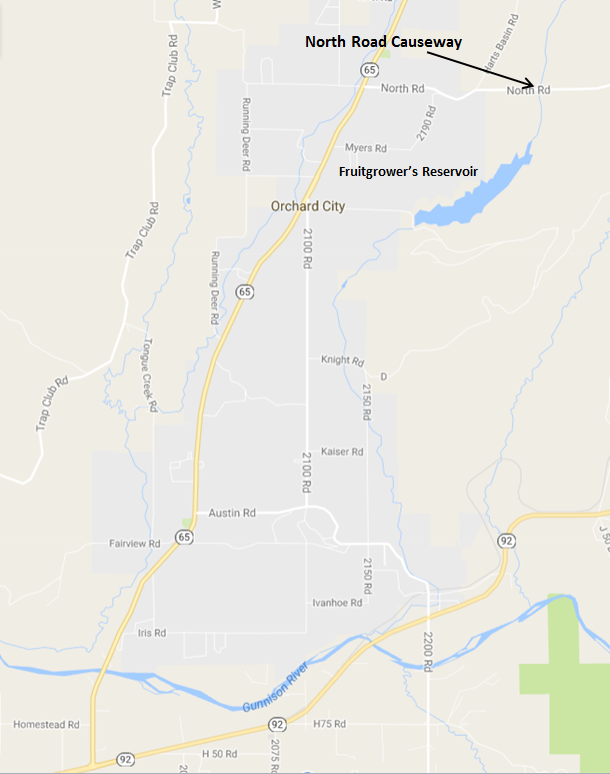
Fruitgrower's Reservoir (also known as Hart’s Basin): North Road (Causeway), Eckert, Delta County
Management: U.S. Bureau of Reclamation; no watercraft are allowed on the reservoir. Private land surrounds BOR land.
Administración: Oficina de Recuperación de los Estados Unidos (BOR); no se permiten embarcaciones en el embalse. Terrenos privados rodean el terreno de la BOR.
Location: The reservoir is approximately 1.1 miles east of the town of Eckert. The main reservoir is on the southern side of North Road (also called N Road) causeway, but during high water, standing water and lush riparian habitat is on the northern side of the causeway.
Ubicación: El embalse se encuentra aproximadamente a 1,1 millas al este de la ciudad de Eckert. El embalse principal se encuentra en el lado sur de la calzada de North Road (también llamada N Road), pero durante las crecidas, el agua estancada y el exuberante hábitat ribereño se encuentran en el lado norte de la calzada.
Directions: From Delta, drive 4 miles east on Highway 92, then turn north on Highway 65 and drive 6 miles to Eckert. Turn right on North Road at Big E Market, which is across from the Eckert Presbyterian Church (large stone church), and proceed east on North Road.
Indicaciones: Desde Delta, conduzca 4 millas al este por la Highway 92, luego gire al norte por la Highway 65 y conduzca 6 millas hasta Eckert. Gire a la derecha en North Road en Big E Market, que está frente a la Iglesia Presbiteriana de Eckert (una gran iglesia de piedra), y continúe hacia el este por North Road.
Accessibility: North Road consists of two-lanes and has a few wide areas on the shoulders where it is safe to park. A large parking area is on the western end of the causeway that provides convenient parking from where you can walk along the causeway or access the western shore of the reservoir. The best viewing is from the causeway. Walking along the western shoreline may cause disturbance to birds. Expect to bird from your car or by carefully walking along the road shoulder. Although traffic volume would be considered low, be aware of rural truck and passenger car traffic. Informational signs are at a large pullout, known locally as Crane Point, on the southern side of the road before you drop down to the reservoir that overlooks farmland. This is on private land, so do not wander far, but this can be a good area to see migrating cranes in the fields below, and dryland bird species may be present as well. Other informational signs are along the causeway.
Accesibilidad: North Road consta de dos carriles y cuenta con algunas zonas amplias en los arcenes donde es seguro estacionar. En el extremo oeste de la calzada hay una amplia zona de aparcamiento que ofrece un cómodo estacionamiento y permite caminar a lo largo de la calzada o acceder a la orilla oeste del embalse. La mejor vista se obtiene desde la calzada. Caminar por la costa oeste puede molestar a las aves. Es posible observar aves desde el coche o caminando con cuidado por el arcén. Aunque el volumen de tráfico se considera bajo, tenga cuidado con el tráfico rural de camiones y vehículos de pasajeros. Hay señales informativas en un amplio apartadero, conocido localmente como Crane Point, en el lado sur de la carretera antes de descender al embalse, con vistas a las tierras de cultivo. Se encuentra en un terreno privado, así que no se aleje demasiado, pero puede ser una buena zona para observar grullas migratorias en los campos de abajo, y también puede haber especies de aves de secano. Hay otras señales informativas a lo largo de la calzada.
Habitat type: The reservoir is bordered by wetlands/riparian areas with scattered trees.
Tipo de hábitat: El embalse está bordeado por humedales/áreas ribereñas con árboles dispersos.
Birds you might see: all varieties of ducks, grebes (including nesting Clark’s grebes), coots; American white pelican, great blue heron; white-faced ibis; double-crested cormorants; terns and gulls; shorebirds include dowitchers, killdeer, lesser and greater yellowlegs, and other migrating rarities; flycatchers; yellow-headed blackbirds; bald and golden eagles; Bullocks orioles; sora; American bittern; warblers; and western kingbird. Sandhill cranes migrate through the area and overnight near the reservoir during March. EBird data show records for 162 species that have been recorded at this location.
Aves que se pueden observar: todas las variedades de patos, zampullines (incluidos los zampullines de Clark que anidan), fochas comunes; pelícano blanco americano, garza azulada; ibis cariblanco; cormoranes de doble cresta; charranes y gaviotas; aves playeras como zarapitos, chorlitos comunes, archibebes menores y mayores, y otras rarezas migratorias; papamoscas; mirlos de cabeza amarilla; águilas calvas y reales; oropéndolas de Bullock; soras; avetoro americano; currucas; y tirano occidental. Las grullas canadienses migran a través de la zona y pernoctan cerca del embalse durante marzo. Los datos de EBird muestran registros de 162 especies registradas en esta ubicación.
Best time of year to visit: March through August. By the end of September, the reservoir has been drawn down and bird populations are too far out to identify without a scope (and difficult even with one).
Mejor época del año para visitar: De marzo a agosto. A finales de septiembre, el embalse se ha vaciado y las poblaciones de aves están demasiado alejadas para identificarlas sin telescopio (e incluso con uno).
More information: Fruitgrower’s Reservoir is recognized as an Important Bird Area of statewide significance by the National Audubon Society. It is also a hotspot on eBird; to find current and annual observations, go to: www.ebird.com Explore Data, click on “Explore Hotspots” and enter Fruitgrower’s Reservoir, North Road Causeway, Delta CO.
Más información: El embalse Fruitgrower’s está reconocido como Área Importante para las Aves de importancia estatal por la Sociedad Nacional Audubon. También es un punto de interés en eBird; para encontrar observaciones actuales y anuales, visite www.ebird.com, explore data, haga clic en "Explore Hotspots" e ingrese "Fruitgrower’s Reservoir, North Road Causeway, Delta, CO".
Comments: There are no rest rooms along the causeway or at the parking area. Travel from the east to west end of the causeway is approximately 0.7 mile. Most waterfowl stay close to shore and are readily identifiable using binoculars, though a spotting scope is of great assistance.
Comentarios: No hay baños a lo largo de la calzada ni en el estacionamiento. El recorrido del extremo este al oeste de la calzada es de aproximadamente 1,1 km. La mayoría de las aves acuáticas permanecen cerca de la orilla y se identifican fácilmente con binoculares, aunque un telescopio terrestre es de gran ayuda.
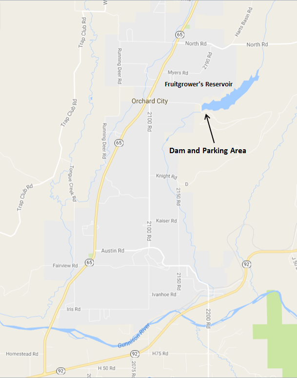
Fruitgrower's Reservoir (Dam Area), Eckert, Delta County
Management: U.S. Bureau of Reclamation. Private land adjacent.
Location: The dam and a parking area with a short paved trail on the southern side of Fruitgrower’s Reservoir is 1 mile east of Highway 65 at Orchard City, about 1 mile south of the town of Eckert. See map below.
Ubicación: La presa y un estacionamiento con un sendero pavimentado corto en el lado sur del embalse Fruitgrower's se encuentran a 1,6 km al este de la autopista 65 en Orchard City, aproximadamente a 1,6 km al sur del pueblo de Eckert. Vea el mapa a continuación.
Directions: From Delta, drive 4 miles east on Highway 92, then turn north on Highway 65 for 5.2 miles. Turn south on County Road 2100 on the eastern side of the highway. Almost immediately (after about 350 ft.) turn left (east) on Fruitgrowers Road (County Road M); there is a sign for Antelope Hill. Follow Fruitgrowers Road for about 1 mile to the dam. To reach the parking area and trail, continue across the dam and continue eastward for about 1,000 ft., taking the left fork onto a dirt road leading to the parking area near the edge of the reservoir.
Indicaciones: Desde Delta, conduzca 6,4 km al este por la Highway 92 y luego gire al norte por la autopista 65 durante 8,4 km. Gire al sur por la carretera County Road 2100 en el lado este de la autopista. Casi inmediatamente (después de unos 106 metros), gire a la izquierda (este) en Fruitgrowers Road (County Road M); hay una señal hacia Antelope Hill. Siga por Fruitgrowers Road durante aproximadamente 1,6 km hasta la presa. Para llegar al estacionamiento y al sendero, cruce la presa y continúe hacia el este durante unos 305 metros, tomando la bifurcación izquierda hacia un camino de tierra que conduce al estacionamiento cerca del borde del embalse.
Accessibility: The roads to the parking area are paved. There is a handicap-accessible walkway approximately 850-feet long that follows the reservoir and ends in a small viewing turnout. Viewing is from the parking area and along the walk-way.
Accesibilidad: Los caminos que llevan al estacionamiento están pavimentados. Hay una pasarela accesible para personas con discapacidad de aproximadamente 267 metros de largo que bordea el embalse y termina en un pequeño mirador. Se puede observar desde el aparcamiento y a lo largo de la pasarela.
Habitat type: Across the reservoir is a forested area with mature trees. Formerly present was a great blue heron rookery and double-crested cormorant nesting area. These have not been used for several years. Below the parking area, are scattered trees and shrubs.
Tipo de hábitat: Al otro lado del embalse se encuentra una zona boscosa con árboles maduros. Anteriormente, existía una colonia de garzas azules y una zona de anidación de cormoranes orejudos. Estas zonas no se han utilizado durante varios años. Debajo del aparcamiento, hay árboles y arbustos dispersos.
Birds you might see: Many varieties of ducks, grebes, coots; great blue herons; belted kingfisher; double-crested cormorants; western kingbird, red-tailed hawk, red-wing blackbirds, doves, and magpies. Ebird has records for 193 species at this location. However, caution, some people mistakenly use this site to record for both the dam and reservoir along North Road, which is accessed through Eckert. See separate description.
Aves que se pueden observar: Diversas variedades de patos, zampullines, fochas comunes; garzas azules; martín pescador ceñido; cormoranes orejudos; tiranos occidentales, gavilán colirrojo, mirlos de alas rojas, tórtolas y urracas. Ebird tiene registros de 193 especies en este lugar. Sin embargo, tenga cuidado, ya que algunas personas utilizan este sitio por error para registrar tanto la presa como el embalse a lo largo de North Road, al que se accede por Eckert. Consulte la descripción por separado.
Best time of year to visit: March through November. By the end of September, the reservoir has been drawn down but from the dam you can walk along the reservoir shoreline as far as you wish – it is rocky and uneven terrain, wear suitable hiking or walking shoes.
Mejor época del año para visitar: De marzo a noviembre. A finales de septiembre el nivel del embalse se habrá reducido, pero desde la presa se puede caminar a lo largo de la orilla del embalse tan lejos como se desee (es un terreno rocoso e irregular, por lo que se deben llevar zapatos adecuados para caminar o hacer senderismo).
More information: This is a hotspot on eBird; to find current and annual observations, go to: www.ebird.com, select “Explore Data,” select “Explore Hotspots,” and enter Fruitgrower’s Reservoir, Delta, CO.
Más información: Este es un punto de interés en eBird; para encontrar observaciones actuales y anuales, visite www.ebird.com, seleccione "Explorar datos", "Explorar puntos de interés" e ingrese "Fruitgrower's Reservoir, Delta, CO".
Comments: Fruitgrower’s Reservoir is recognized as an Important Bird Area of statewide significance by the National Audubon Society. As compared to viewing along the North Road causeway on the northern end of the reservoir, this location typically has fewer species present during the summer; it is best visited in conjunction with a visit to the northern end of the reservoir outside of Eckert. In the fall, when the reservoir has receded and birds cannot be identified without a scope, walking along the exposed shoreline by the dam offers potential sightings.
Comentarios: El Fruitgrower's Reservoir está reconocido como Área Importante para las Aves de importancia estatal por la Sociedad Nacional Audubon. En comparación con la observación a lo largo de la calzada de North Road en el extremo norte del embalse, este lugar suele tener menos especies presentes durante el verano; se recomienda visitarlo junto con una visita al extremo norte del embalse, a las afueras de Eckert. En otoño, cuando el nivel del agua del embalse ha disminuido y no se pueden identificar las aves sin un telescopio, caminar por la costa expuesta junto a la presa ofrece la posibilidad de avistar aves.
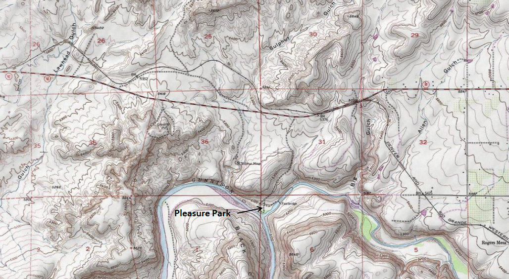
Pleasure Park at the Confluence of the North Fork of the Gunnison and Gunnison Rivers, Delta County
Management: Bureau of Land Management
Location: From Delta: Drive east on Hwy 92 approximately 14 miles to Pleasure Park Rd. There is a BLM sign. Turn right and drive early a mile to end of road where there is a small graveled parking area. From Hotchkiss: Drive toward Delta west on Hwy 92 approximately 5 miles to Pleasure Park Rd.
Ubicación: Desde Delta: Conduzca hacia el este por la autopista 92 aproximadamente 22,5 km hasta Pleasure Park Rd. Hay una señal de la Oficina de Gestión de Tierras (BLM). Gire a la derecha y conduzca temprano 1,6 km hasta el final de la carretera, donde encontrará un pequeño estacionamiento de grava. Desde Hotchkiss: Conduzca hacia Delta hacia el oeste por la autopista 92 aproximadamente 8 km hasta Pleasure Park Rd.
Accessibility: Road is paved nearly to parking area, accessible to all cars. If conditions are very wet, spur roads from the parking area may be slippery, depending on when gravel was last applied. Look for a rough trail through the willows along the river heading upstream. There are no services but there is a privately owned public business establishment, Gunnison River Pleasure Park, to the west. They sell fishing gear and refreshments.
Accesibilidad: La carretera está pavimentada casi hasta el estacionamiento y es accesible para todos los vehículos. Si las condiciones están muy húmedas, los ramales que salen del estacionamiento pueden estar resbaladizos, dependiendo de cuándo se aplicó la grava por última vez. Busque un sendero irregular entre los sauces a lo largo del río río arriba. No hay servicios, pero hay un establecimiento comercial público privado, Gunnison River Pleasure Park, al oeste. Venden artículos de pesca y refrigerios.
Habitat: Riparian, Wooded/brushy riparian, high desert in the hills.
Hábitat: Ribereño, ribereño boscoso/con arbustos, desierto alto en las colinas.
Birds you might see: Waterfowl, riparian songbirds, wading birds, raptors, and chukar.
Aves que se pueden observar: Aves acuáticas, aves cantoras ribereñas, aves zancudas, rapaces y perdices chukar.
Best time of year: Spring migration, though it’s good year round.
Mejor época del año: Migración de primavera, aunque es buena durante todo el año.
Aspen Habitat – Stevens Gulch/Mule Park/Buzzard-Muddy Creek Divide, Delta and Gunnison Counties
Managed by: Grand Mesa, Uncompahgre, and Gunnison National Forest
Location: North of Paonia
Ubicación: Al norte de Paonia
Directions: From Hwy 133 in Paonia, go north on Stevens Gulch Rd (opposite Hwy 187 at the east access to Paonia from Hwy 133) until you hit aspens at the forest boundary. Continue northerly, with Hubbard Park being an often worthwhile stop. Continue until you hit FR 265. (This intersection is about 17 miles north of the intersection of Hwy 133 and Stevens Gulch Rd, where we started, as the crow flies, but much more than that on the odometer.) Turning right/east here takes you through nice aspen habitat, and back to Hwy 133, southwest of McClure Pass. Turning left/west at the junction of Stevens Gulch Rd and FR 265, takes you to excellent pure aspen/open park habitat in Mule Park, over Buzzard-Muddy Divide, and down Buzzard Creek to Silt or Collbran.
Indicaciones: Desde la Hwy 133 en Paonia, diríjase hacia el norte por Stevens Gulch Rd (frente a la Hwy 187 en el acceso este a Paonia desde la Hwy 133) hasta llegar a los álamos en el límite del bosque. Continúe hacia el norte; el Parque Hubbard es una parada que suele merecer la pena. Continúe hasta llegar a la autopista FR 265. (Esta intersección está a unos 27 kilómetros al norte de la intersección de la Hwy 133 y Stevens Gulch Rd, donde comenzamos, en línea recta, pero mucho más que eso en el odómetro). Girar a la derecha/este aquí le llevará a través de un hermoso hábitat de álamos y de regreso a la Hwy 133, al suroeste del Paso McClure. Girar a la izquierda/oeste en el cruce de Stevens Gulch Rd y la autopista FR 265 le llevará a un excelente hábitat de álamos puros/parque abierto en el Parque Mule, sobre la Divisoria Buzzard-Muddy y bajando por el arroyo Buzzard hasta Silt o Collbran.
Accessibility: Gravel roads, closed in winter, can be treacherous November through early May. High clearance is preferable, but 2WD cars can handle the main roads in summer.
Accesibilidad: Los caminos de grava, cerrados en invierno, pueden ser peligrosos de noviembre a principios de mayo. Es preferible una distancia al suelo elevada, pero los vehículos con tracción en las dos ruedas (2WD) pueden transitar por las carreteras principales en verano.
Habitat type: Pure or climax aspen. Also aspen/conifer mix, spruce/fir, mid elevation riparian, and open parkland. The edges of the aspens and open parks are the most unique areas here, especially for birds such as purple martins that hunt in open country, but live in aspen cavities.
Hábitat: Álamo temblón puro o clímax. También se encuentran mezclas de álamo temblón y coníferas, abetos, riberas de mediana altitud y parques abiertos. Los límites de los álamos y los parques abiertos son las zonas más singulares, especialmente para aves como los aviones purpúreos, que cazan en campo abierto, pero viven en cavidades de álamo.
Birds you might see: Aspen cavity nesters, including western purple martin, violet-green and tree swallows, mountain bluebird, house wren, northern flicker, red-naped sapsucker, downy, and hairy woodpecker. Also western wood-pewee, and warbling vireo. Spruce-fir birds include gray jay, red crossbill, ruby-crowned kinglet, yellow-rumped warbler, hermit thrush and three-toed woodpecker. Swainson's hawk is possible in aspen-ringed parks, and red-tailed hawk and American kestrel are very common. Peregrine falcon and northern goshawk breed here but are less common. Willow flycatcher, cedar waxwing and fox sparrow are in some riparian areas, along with more common Lincoln’s, song, and white-crowned sparrow, and yellow warbler. Also numerous flammulated, northern saw-whet and boreal owls can be heard at night during breeding season.
Aves que se pueden observar: Aves que anidan en cavidades de álamo, como el avión purpúreo occidental, las golondrinas verdivioletas y arbóreas, el azulejo de montaña, el cucarachero común, el carpintero norteño, el chupasavia nuquirrojo, el pájaro carpintero velloso y el pájaro carpintero peludo. También el pibí occidental y el vireo gorjeador. Entre las aves que viven en los bosques de abetos se encuentran el arrendajo gris, el piquituerto rojo, el reyezuelo coronirrubí, la reinita rabadilla amarilla, el zorzal ermitaño y el pájaro carpintero tridáctilo. El gavilán de Swainson es posible en los parques rodeados de álamos, y el gavilán colirrojo y el cernícalo americano son muy comunes. El halcón peregrino y el azor norteño se reproducen aquí, pero son menos comunes. El papamoscas sauce, el ampelis cedro y el gorrión zorro se encuentran en algunas zonas ribereñas, junto con los más comunes gorriones de Lincoln, el gorrión cantor, el gorrión coroniblanco y la reinita amarilla. También se pueden avistar numerosos búhos flammulados, cariblancos y boreales por la noche durante la temporada de cría.
Best time of year: Late May through late July is best for most migratory species such as purple martins. Mid July is great for viewing martins and other species feeding young. Mid to late May is good for owls.
Mejor época del año: De finales de mayo a finales de julio es la mejor época para la mayoría de las especies migratorias, como los aviones purpúreos. Mediados de julio es ideal para observar aviones y otras especies alimentando a sus crías. De mediados a finales de mayo es ideal para los búhos.
More information: N/A

Gunnison County
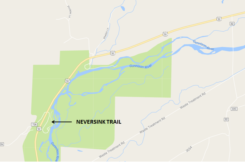
Neversink Trail, Gunnison County
Managed by: Curecanti National Recreation Area, National Parks Service
Location: 5.7 miles west of Gunnison, or 58.9 miles east from Montrose, on the south side of Highway 50
Ubicación: 9,2 km al oeste de Gunnison o 94,5 km al este de Montrose, al sur de la autopista 50.
Directions: From Gunnison, take Highway 50 west towards Montrose. Once out of town, turn left (south) into the Neversink trailhead access. If you reach the first bridge on Blue Mesa (Highway 149), you have gone too far! If you are approaching from Montrose, the Neversink turn will be on your right almost immediately after getting out of the Gunnison River Canyon (which is the canyon right after the turn to Highway 149 – the turn is 3.9 miles after you cross Highway 149).
Indicaciones: Desde Gunnison, tome la autopista 50 oeste hacia Montrose. Al salir del pueblo, gire a la izquierda (sur) hacia el acceso al sendero Neversink. Si llega al primer puente en Blue Mesa (autopista 149), ¡se ha pasado! Si viene desde Montrose, el giro hacia Neversink estará a su derecha casi inmediatamente después de salir del cañón del río Gunnison (el cañón justo después del giro hacia la autopista 149; el giro está a 6,3 km después de cruzar la autopista 149).
Accessibility: Paved, no 4WD or high clearance needed! Accessible to all cars, and no entrance fee required. The trail itself is unpaved but flat (only 13 feet of elevation gain across 1.3 miles). The trail is considered wheelchair friendly, but is not plowed, so in winter and spring the trail can be quite slippery.
Accesibilidad: Pavimentado, no se necesita 4x4 ni altura libre al suelo. Accesible para todo tipo de vehículos y sin pago de entrada. El sendero es de tierra, pero plano (solo 4 metros de desnivel positivo a lo largo de 2,1 km). El sendero se considera apto para sillas de ruedas, pero no está arado, por lo que en invierno y primavera puede estar bastante resbaladizo
Habitat type: Riparian
Tipo de hábitat: Ribereño
Birds you might see: Riparian songbirds, warblers, shorebirds, waterfowl, herons (nearby rookery), eagles, other raptors, dippers
Aves que se pueden observar: Aves cantoras ribereñas, currucas, aves playeras, aves acuáticas, garzas (colonia cercana), águilas, otras aves rapaces, mirlos acuáticos
Best time of year: All year! Especially in fall, as the cottonwoods are especially vibrant that time of year!
Mejor época del año: ¡Todo el año! Sobre todo en otoño, ya que los álamos están especialmente vibrantes en esa época.
More information: http://www.alltrails.com/trail/us/colorado/neversink-trail
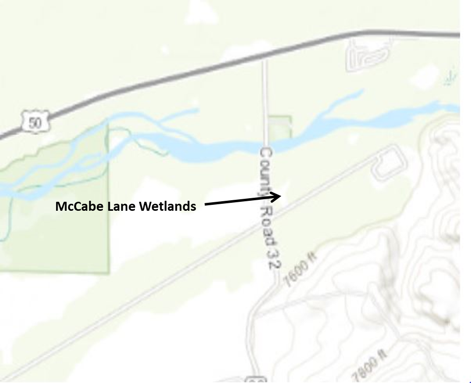
McCabe Lane Wetlands, Gunnison County
Managed by: City of Gunnison
Location: 4.5 miles west of Gunnison
Ubicación: 7,2 km al oeste de Gunnison
Directions: From Gunnsion, take US Highway 50 4.5 miles west towards Blue Mesa Reservoir. Watch for a left turn lane for County Road 32 and a sign for Riverway river access. Drive south approximately ¾ of a mile, passing over the Gunnison River and take the first left turn into a gravel parking area with a hand-painted McCabe Lane Wetlands sign. Coming from Montrose, look for the Riverway sign approximately 2 miles past the Neversink Day Use Area of the Curecanti National Recreation Area.
Indicaciones: Desde Gunnison, tome la US Hwy 50 durante 7,2 km al oeste hacia el embalse Blue Mesa. Esté atento al carril de giro a la izquierda hacia la carretera del condado 32 y a la señal de acceso al río Riverway. Conduzca hacia el sur aproximadamente 0,7 km, cruzando el río Gunnison, y tome la primera salida a la izquierda hacia un estacionamiento de grava con un letrero pintado a mano de los Humedales de McCabe Lane. Si viene de Montrose, busque el letrero de Riverway aproximadamente 3 km después del área de uso diurno Neversink del Área Recreativa Nacional Curecanti.
Accessibility: Access to the area is free. A dirt path leads to the east toward an old metal building before it diverges into a couple of dirt paths leading to several ponds and the riparian area bordering the Gunnison River. Although level ground, the narrow trails are not handicap accessible, and there are no restrooms at the site.
Accesibilidad: El acceso al área es gratuito. Un sendero de tierra conduce al este hacia una antigua construcción metálica antes de desviarse hacia un par de senderos de tierra que conducen a varios estanques y a la zona ribereña que bordea el río Gunnison. Aunque el terreno es llano, los senderos estrechos no son accesibles para personas con discapacidad y no hay baños en el sitio.
Habitat: Starting in a weedy meadow, most of the area consists of several willow and/or cattail-lined ponds, one of them being several acres in size. A short portion of one of the trails briefly enters a cottonwood-dominated riparian area.
Hábitat: Comenzando en una pradera con maleza, la mayor parte del área consiste en varios estanques rodeados de sauces y/o espadañas, uno de ellos de varias hectáreas de extensión. Un pequeño tramo de uno de los senderos se adentra brevemente en una zona ribereña dominada por álamos.
Birds you might see: As expected, these wetlands attract a variety of ducks and other wetland-associated birds, such as tree and violet-green swallows, marsh wrens, red-winged blackbirds, McGillivray’s, yellow, and Wilson’s warblers, and great blue herons. Bald eagles, red-tailed hawks, and Swainson’s hawk’s (in summer) are often seen flying over the area. Sparrows are common, including chipping, song, and Lincoln’s in summer and white-crowned and American tree sparrows in late fall. Over 170 species have been reported at this location according to eBird.
Aves que se pueden observar: Como es de esperar, estos humedales atraen a una variedad de patos y otras aves asociadas a los humedales, como golondrinas arbóreas y golondrinas verde-violetas, cucaracheros palustres, mirlos de alas rojas, reinitas de McGillivray, reinitas amarillas y de Wilson, y garzas azules. Águilas calvas, gavilanes de cola roja y gavilanes de Swainson (en verano) se avistan con frecuencia sobrevolando la zona. Los gorriones son comunes, incluyendo el gorrión trinador, el gorrión cantor y el gorrión de Lincoln en verano, y el gorrión de corona blanca y el gorrión arbóreo americano a finales del otoño. Se han reportado más de 170 especies en este lugar según eBird.
Best time of the year: Fall and spring are the best time to visit in order to see the largest number of ducks and other wetland species. Summer can also be productive.
Mejor época del año: Otoño y primavera son la mejor época para visitarlo y observar la mayor cantidad de patos y otras especies de humedales. El verano también puede ser productivo.
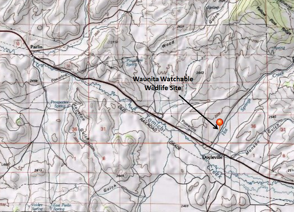
Waunita Watchable Wildlife Site, Gunnison County
Managed by: Colorado Parks and Wildlife
Location: 19 miles east of Gunnison, ½ mile north from US Highway 50
Directions: From Gunnison, take Highway 50 east for 19 miles and turn north (left) onto County Road 887 towards Waunita Hot Springs. Go 0.6 miles to a small pull-off on the right, where you can sit in your car to view birds.
Indicaciones: Desde Gunnison, tome la autopista 50 este durante 30 kilómetros y gire al norte (izquierda) hacia la carretera del condado 887 en dirección a Waunita Hot Springs. Continúe 1 kilómetro hasta un pequeño desvío a la derecha, donde podrá sentarse en su coche para observar aves.
Accessibility: County road is gravel, so site is accessible to all cars. However, accessibility is somewhat limited by space due to a short lekking season. To ensure that you can view the lek, show up well before the required arrival time (one hour before sunrise). Check the schedule before going to be sure you are not visiting on a day that is closed to the public (in an effort to reduce impacts to the birds). Accessible to all cars, no entrance fee required. However, if you would like to use the private viewing blind, contact Sisk-A-Dee (see website below). Additionally, visitors are encouraged to purchase Habitat Stamps from Colorado Parks and Wildlife to support wildlife viewing opportunities across the state, like this!
Accesibilidad: La carretera del condado es de grava, por lo que el sitio es accesible para todos los coches. Sin embargo, la accesibilidad es algo limitada por el espacio debido a la corta temporada de lek. Para asegurarse de poder ver el lek, llegue con bastante antelación a la hora de llegada requerida (una hora antes del amanecer). Consulte el horario antes de ir para asegurarse de no visitarlo en un día cerrado al público (para reducir el impacto en las aves). Accesible para todos los coches; la entrada es gratuita. Sin embargo, si desea utilizar el puesto de observación privado, póngase en contacto con Sisk-A-Dee (consulte el sitio web a continuación). Además, se anima a los visitantes a comprar sellos de hábitat de Parques y Vida Silvestre de Colorado para apoyar las oportunidades de observación de vida silvestre en todo el estado, como esta.
Habitat type: Sagebrush and irrigated meadow
Tipo de hábitat: Artemisa y pradera de regadío
Birds you might see: Gunnison Sage-Grouse! This is the only public viewing site in the world to see these birds. In addition, you may see a variety of sagebrush songbirds, red-winged blackbirds, Wilson’s snipe, corvids and raptors.
Aves que podría ver: ¡Urogallo de las artemisas de Gunnison! Este es el único sitio público de observación en el mundo donde se pueden observar estas aves. Además, podrá observar una variedad de pájaros cantores de la artemisa, mirlos de alas rojas, agachadizas de Wilson, córvidos y aves rapaces.
Best time of year: April 1 to May 10, visitors MUST arrive at least one hour before sunrise
Mejor época del año: Del 1 de abril al 10 de mayo. Los visitantes DEBEN llegar al menos una hora antes del amanecer.
More information: http://www.siskadee.org/view.htm - please visit this website before visiting Waunita, as it provides very important information on the viewing protocol. These guidelines were established to ensure that visitors follow ethical guidelines to minimize disturbance to the birds.
Más información: http://www.siskadee.org/view.htm - Visite este sitio web antes de visitar Waunita, ya que proporciona información muy importante sobre el protocolo de observación. Estas directrices se establecieron para garantizar que los visitantes sigan las normas éticas y minimicen las molestias a las aves.
Montrose County
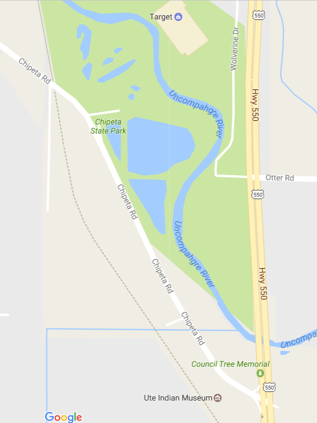
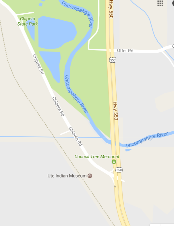
Chipeta Lake, Montrose
Management: City of Montrose
Location: Approximately three miles south of downtown Montrose.
Ubicación: Aproximadamente a tres millas al sur del centro de Montrose.
Directions: Follow Colorado Highway 550 south out of Montrose. After passing the Target Shopping Center, stay in right hand lane. Turn right with exit lane onto Chipeta Road. You will cross over the Uncompaghre River bridge before making turn. The Ute Indian Museum is on the immediate left. Continue north on Chipeta Road less than one mile. The lake is on the right side of road, with several dirt pull-outs; there is heavy traffic on Chipeta Road, so be careful pulling on and off. A parking area is on the northern end of the lake, accessed from Chipeta Road by Old Chipeta Trail.
Indicaciones: Salga de Montrose por la carretera Colorado Highway 550 hacia el sur. Después de pasar el centro comercial Target, manténgase en el carril derecho. Gire a la derecha en el carril de salida hacia Chipeta Road. Cruzará el puente sobre el río Uncompaghre antes de girar. El Museo Indio Ute está inmediatamente a la izquierda. Continúe hacia el norte por Chipeta Road menos de una milla. El lago está a la derecha de la carretera, con varios accesos de tierra; hay mucho tráfico en Chipeta Road, así que tenga cuidado al entrar y salir. Hay un estacionamiento en el extremo norte del lago, al que se accede desde Chipeta Road por el sendero Old Chipeta Trail.
Accessibility: The dirt pull offs are mostly flat. These offer the best view points of lake. If you choose to go around the lake, you must descend a flight of stairs or drive around to the parking area on the northern side. A dirt trail can be followed around lake, which also provides access to the Uncompahgre River.
Accesibilidad: Los accesos de tierra son mayormente planos. Ofrecen las mejores vistas del lago. Si decide rodear el lago, debe bajar un tramo de escaleras o conducir hasta el estacionamiento en el lado norte. Se puede seguir un sendero de tierra alrededor del lago, que también da acceso al río Uncompahgre.
Habitat type: A small lake with a spillway dam and some “improvements.” It is stocked with trout each spring. The roadside pull-outs have tall bushes blocking much of the view, but there are several good openings between them. If you remain in your vehicle, birds on the water are less likely to be spooked. The lake is heavily used by people fishing, spring through fall, with an occasional small water-craft. The lake usually freezes over in winter during cold snaps, but sometimes the southern end remains open and is a good place to see waterfowl and bald eagles.
Tipo de hábitat: Un pequeño lago con un aliviadero y algunas mejoras. Se repobla con truchas cada primavera. Los paraderos junto a la carretera tienen arbustos altos que bloquean gran parte de la vista, pero hay varios claros entre ellos. Si permanece en su vehículo, es menos probable que las aves en el agua se asusten. El lago es muy frecuentado por pescadores, de primavera a otoño, con alguna pequeña embarcación ocasional. El lago suele congelarse en invierno durante las olas de frío, pero a veces el extremo sur permanece abierto y es un buen lugar para observar aves acuáticas y águilas calvas.
Birds you might see: One of the better birding spots in the Uncompaghre Valley. Numerous duck species can be seen fall through spring and during winter when lake is not frozen. A variety of song birds can be found in the shrubs and trees during migration and summer. In winter look for bald eagles. Osprey, kingfishers, and a vagrant cormorant have been seen here. Chipeta Lake is an eBird hotspot with over 60 species recorded.
Aves que podría observar: Uno de los mejores lugares para observar aves en el valle de Uncompaghre. Se pueden observar numerosas especies de patos de otoño a primavera y durante el invierno, cuando el lago no está congelado. Se puede observar una variedad de aves cantoras en los arbustos y árboles durante la migración y el verano. En invierno, busque águilas calvas. Aquí se han avistado águilas pescadoras, martines pescadores y un cormorán errante. El lago Chipeta es un punto de acceso de eBird con más de 60 especies registradas.
Ute Indian Museum Grounds and Native Garden, Montrose
Terrenos del Museo Indio Ute y Jardín Nativo, Montrose
Management: History Colorado, a division of the Colorado State Government.
Location: Approximately three miles south of downtown Montrose.
Ubicación: Aproximadamente a tres millas al sur del centro de Montrose.
Directions: Follow Colorado Highway 550 south out of Montrose. After passing the Target Shopping Center, stay in the right-hand lane. Follow the turn lane onto Chipeta Road. The Museum is on the immediate left and is well worth visiting. The museum has extensive tree-covered grounds on the west side of the road and a native garden on the east side of the road with access to the Uncompaghre River.
Indicaciones: Salga de Montrose por la carretera Colorado Highway 550 hacia el sur. Después de pasar el centro comercial Target, manténgase en el carril derecho. Siga el carril de giro hacia Chipeta Road. El museo está inmediatamente a la izquierda y vale la pena visitarlo. El museo cuenta con un extenso terreno arbolado al oeste de la carretera y un jardín autóctono al este, con acceso al río Uncompaghre.
Accessibility: Ample parking is in front of the museum with handicap parking spaces. The museum grounds to the north of the museum are fairly level, with an extensive grassy lawn and sandy-gravel walking paths. Use the crosswalk to access the native garden on the eastern side of Chipeta Road; watch for fast, heavy traffic at times. A flight of stairs descends into the garden. The garden can also be accessed from a small parking lot at the north end where stairs are not needed but the trail is not flat and may not meet ADA standards. Note: The trails in the garden area are graveled. A wooden bridge with steps on each side and a boardwalk with steps lead into a wetlands area along the Uncompahgre River.
Accesibilidad: Hay un amplio estacionamiento frente al museo, con plazas para personas con discapacidad. El terreno del museo, al norte, es bastante llano, con una extensa zona de césped y senderos de arena y grava. Utilice el cruce peatonal para acceder al jardín autóctono, ubicado al este de Chipeta Road; tenga cuidado con el tráfico intenso. Un tramo de escaleras desciende hasta el jardín. También se puede acceder al jardín desde un pequeño estacionamiento en el extremo norte, donde no se necesitan escaleras, pero el sendero no es plano y podría no cumplir con las normas de la ADA. Nota: Los senderos del jardín son de grava. Un puente de madera con escalones a cada lado y una pasarela con escalones conducen a una zona de humedales junto al río Uncompahgre.
Habitat: The grounds of the museum are like a city park with large expanses of grass and mature deciduous and coniferous trees. The garden area across the street has a collection of native and non-native flowers, shrubs, and trees. On the eastern edge of the garden is a row of very large Siberian elm trees. A small stream and pond are in the garden. A boardwalk and numerous wooden stairs at the north end of the garden will take you down to the flood plain of the Uncompahgre River with an extensive cattail marsh. There are viewing platforms and benches.
Hábitat: Los terrenos del museo se asemejan a un parque urbano, con amplias extensiones de césped y árboles caducifolios y coníferos maduros. El jardín, al otro lado de la calle, alberga una colección de flores, arbustos y árboles autóctonos y no autóctonos. En el extremo este del jardín se encuentra una hilera de olmos siberianos de gran tamaño. Un pequeño arroyo y un estanque se encuentran en el jardín. Una pasarela y numerosas escaleras de madera en el extremo norte del jardín conducen hasta la llanura aluvial del río Uncompahgre, con una extensa ciénaga de espadañas. Hay plataformas de observación y bancos.
Birds you might see: The variety of habitat plus the small riparian area attracts numerous song birds through migration and the summer months into early September. Birds such as swallows, goldfinches, siskins, hummingbirds, warblers, waxwings, and a variety of birds of prey can be seen. The museum is an eBird hotspot with over 50 species recorded.
Aves que se pueden observar: La variedad de hábitats, además de la pequeña zona ribereña, atrae a numerosas aves cantoras durante la migración y durante los meses de verano, hasta principios de septiembre. Se pueden observar aves como golondrinas, jilgueros, lúganos, colibríes, currucas, ampelis y diversas aves rapaces. El museo es un punto de acceso de eBird con más de 50 especies registradas.
Best time of year to visit: Spring and summer.
Mejor época del año para visitarlo: Primavera y verano.
More information: http://www.historycolorado.org/museums/ute-indian-museum-0
Comments: Chipeta, the famous wife of the Ute Chief Ouray, is entombed on the grounds. A natural spring, now found inside a concrete tipi, was used by the Dominguez and Escalante Expedition in 1776. The spring was used extensively by the Ute People for centuries and is still used today by modern Utes. The museum grounds are held in reverence by today’s Utes. Please be respectful of this historically significant site.
Comentarios: Chipeta, la famosa esposa del jefe ute Ouray, está enterrada en el recinto. Un manantial natural, ahora ubicado dentro de un tipi de concreto, fue utilizado por la expedición de Domínguez y Escalante en 1776. El manantial fue ampliamente utilizado por el pueblo ute durante siglos y aún lo utilizan los utes modernos. Los utes actuales veneran el recinto del museo. Por favor, respete este sitio de importancia histórica.
Marine Road Park (Marine Road Wildlife Area), Montrose County
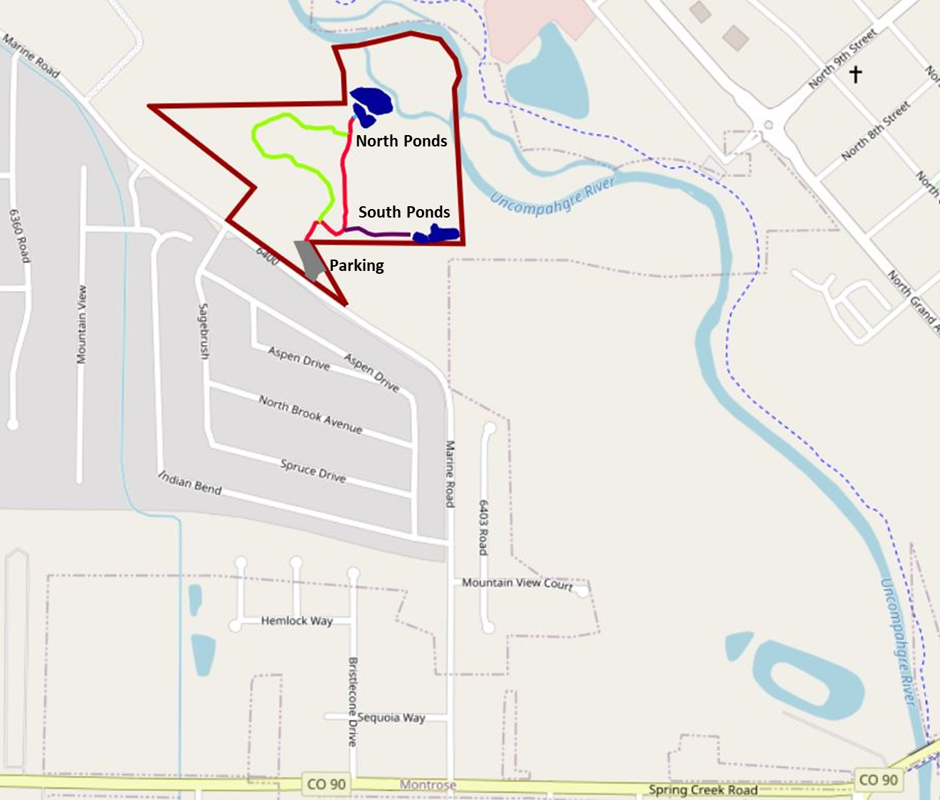
Managed By: City of Montrose Public Works, Parks Division
Location: West of Montrose, west of the Uncompahgre River, and adjacent to the northeastern side of Marine Road
Directions: Starting at the corner of Townsend Avenue and Main Streets in Montrose, drive approximately one mile west on Main Street (changes to Spring Creek Road/State Highway 90) to the traffic light that is signed Marine Road. Turn right (north) onto Marine Road and continue approximately 0.5 mile. Watch for a large, graveled parking lot on the northeastern side of Marine Road. The property does not have an entrance sign.
Accessibility: Park in the graveled parking lot and continue through the perimeter fence to access three short, bark-mulch-covered trails. The North Pond Trail ends at a bird blind that provides good views of two ponds and also a portion of the Uncompahgre River. The South Pond Trail leads to two ponds on the southern end of the property, and a third trail (Upland Trail) skirts through grassland and open meadows and ends at a connection with the trail to the bird blind. The combined trail walking distance is approximately 1.5 miles. No water or restroom facilities are on the property, and the property is not ADA-compliant. The nearest facilities are in a convenience store at the Marine Road traffic light.
Habitat Type: the most valuable birding habitat occurs along a riparian corridor dominated by old Russian olive trees. This habitat includes a large drainage that has open water year-round. The drainage continues through the south ponds and feeds the two large north ponds. The area along the drainage contains native phragmites reeds, which can be impenetrable during parts of the year.
The upland area begins at the entrance and continues through much of the central portion of the property. It contains a mix of open meadows with grasses, reeds, and shrubs, some small patches of native wild iris, milkweed, and scattered Russian olive trees. This area is traversed by a trail that departs the main trail that accesses the south and north ponds. The upland trail is the left fork immediatly after crossing the entrance culvert.
Wildlife such as deer, coyote, and fox are occasionally seen throughout the property. Beavers are active in some areas along the drainages.
Birds You Might See: Over 140 bird species have been recorded foraging or nesting on the property or have been spotted flying over the property. Virginia Rails are commonly heard most of the year and occasionally a Sora may be heard or seen. Warblers such as the Common Yellowthroat, Yellow Warbler, Wilson’s Warbler, or Yellow-rumped Warblers may be present in the summer or passing through as fall migrants. Black-headed Grosbeaks and Western Kingbirds are often seen during the summer along with a wide variety of swallows and Black-chinned Hummingbirds. Marsh Wrens may be present year-around, but are most common during the cooler months. Large flocks of Canada geese are heard and seen flying south along the nearby river corridor during the fall and winter, as they access nearby fields to forage. Great Blue Herons, Red-winged Blackbirds, Song Sparrows, and Belted Kingfishers are common residents throughout the year. Because the ponds and connecting waterways do not freeze, the area is particularly good for migrating waterfowl.
Best time to visit: Most times of the year offer a reasonably good birding experience. The habitat is wilder and more diverse than other birding locations in the Montrose area. This is a good location to see winter birds and ducks due to the continued presence of surface water in the drainages and ponds year round. Winter ducks spotted over the years include Cinnamon Teal, Northern Shoveler, Gadwall, American Wigeon, Mallards, Ring-necked Ducks, and Green-winged Teal, but numerous other duck species have been seen. It can be a good area to see spring and fall migrants.
Comments: In the future, this 20-acre property will be restored and maintained for wildlife use and will be renamed the Marine Road Wildlife Area. It is unlikely that the eBird name, Marine Road Park, will change.
At the time of this writing (August 2025) the City of Montrose is seeking a grant to fund a contractor that will design and construct an ADA-compliant ramp and bird blind to the south ponds as well as restore the entire site and parking lot to meet ADA compliance standards.
East Fork of Dry Creek, Uncompahgre Plateau, Montrose County
Management: Bureau of Land Management, Uncompahgre Field Office.
Location: The area is about 15 miles southwest of Montrose at the crossing of the East Fork of Dry Creek by Highway 90 on the Uncompahgre Plateau.
Ubicación: El área se encuentra a unos 24 kilómetros al suroeste de Montrose, en el cruce de la bifurcación este de Dry Creek con la Highway 90 en la meseta de Uncompahgre.
Directions: From the intersection of Main St. and Townsend Ave. in Montrose, take West Main St. westward for 2 miles, keeping right at the intersection with Chipeta Road where Main St. transitions to Highway 90, and turn left at the top of the hill where Highway 90 begins its zigzag route across Spring Creek Mesa. After 4.5 miles of multiple turns across the mesa, Highway 90 enters Shavano Valley. Continue westward about 1.4 miles along and across Shavano Valley, continuing on Highway 90 to the left past the intersection from the south of Shavano Valley Road, whereupon the pavement ends and the road begins to climb onto the Uncompahgre Plateau. Continue westward on Highway 90 for about 6.8 miles to the edge of the canyon of Dry Creek. Continue about 0.3 miles to the bottom of the canyon and cross the East Fork of Dry Creek and park on the left side of the road. Birding is best from the parking area southward and from highway 90 to the north, looking down into the shrubs and trees along the creek.
Indicaciones: Desde la intersección de Main St. y Townsend Ave. en Montrose, tome West Main St. hacia el oeste durante 3 kilómetros, manteniéndose a la derecha en la intersección con Chipeta Road, donde Main St. se une a la Highway 90. Gire a la izquierda en la cima de la colina, donde la Highway 90 comienza su ruta en zigzag a través de Spring Creek Mesa. Después de 7 kilómetros de múltiples curvas a través de la mesa, la Highway 90 ingresa al valle de Shavano. Continúe hacia el oeste unos 2,2 kilómetros a lo largo y a través del valle de Shavano, continuando por la Highway 90 a la izquierda, pasando la intersección desde el sur de Shavano Valley Road, donde termina el pavimento y la carretera comienza a ascender hacia la meseta de Uncompahgre. Continúe hacia el oeste por la Highway 90 durante unos 10 kilómetros hasta el borde del cañón de Dry Creek. Continúe aproximadamente 0,3 millas hasta el fondo del cañón, cruce la bifurcación este de Dry Creek y estacione a la izquierda de la carretera. La observación de aves es mejor desde el estacionamiento hacia el sur y desde la carretera 90 hacia el norte, observando los arbustos y árboles a lo largo del arroyo.
Accessibility: The parking area and informal trails to the south access excellent habitat and walking the shoulder of Highway 90 above the creek to the north provides excellent viewing. There is not much traffic, but beware of vehicles on the road. Informal trails penetrate the vegetation short distances southward from the parking area.
Accesibilidad: El estacionamiento y los senderos informales al sur ofrecen acceso a un hábitat excelente. Caminar por el arcén de la Carretera 90, sobre el arroyo hacia el norte, ofrece una vista excelente. Hay poco tráfico, pero tenga cuidado con los vehículos en la carretera. Los senderos informales se adentran en la vegetación a poca distancia hacia el sur del estacionamiento.
Habitat type: The creek provides dense riparian habitat of willows, aspen, and cottonwoods with tall conifers on the margins. Pinyon-juniper forest covers the surrounding area.
Tipo de hábitat: El arroyo ofrece un denso hábitat ribereño de sauces, álamos temblones y álamos americanos, con coníferas altas en los márgenes. El bosque de piñones y enebros cubre el área circundante.
Birds you might see: A wide variety of passerines are present, including warblers (Virginia’s, yellow, and yellow-rumped), flycatchers (western wood-pewee, olive-sided), nuthatches, hermit thrush, house wren, warbling vireo, ruby-crowned kinglet, mountain chickadee, chipping sparrow, violet-green swallow, house wren, and juncos. Woodpeckers (northern flicker, red-naped and Williamson’s sapsucker), broad-tailed hummingbird, and hermit thrush are possible. A band-tailed pigeon was seen flying through the area a few years ago.
Aves que puede observar: Se encuentra presente una amplia variedad de paseriformes, incluyendo reinitas (de Virginia, amarillas y de rabadilla amarilla), papamoscas (de la familia del palomo occidental y de flancos oliváceos), trepadores azules, zorzales ermitaños, cucaracheros comunes, vireos cantores, reyezuelos de corona rubí, carboneros de montaña, gorriones chipeadores, golondrinas verdivioletas, cucaracheros comunes y juncos. Se pueden observar pájaros carpinteros (el carpintero norteño, el carpintero nuquirojo y el chupasavia de Williamson), colibríes colibríes y zorzales ermitaños. Hace unos años se avistó una paloma de cola anillada sobrevolando la zona.
Best time of year to visit: Spring and summer to catch migrants and nesting birds.
Mejor época del año para visitar: Primavera y verano para observar aves migratorias y anidadoras.
More information: Areas farther west on Highway 90 include Silesca Pond, where a sora is sometimes present, and Buck Trail, where three-toed woodpeckers have been seen. Look for clearings in the woods along the road for bird activity with a wide variety of birds possible, including nuthatches, western bluebirds, crossbills, flycatchers, and others.
Más información: Las zonas más al oeste de la Carretera 90 incluyen el Estanque Silesca, donde a veces se encuentra una sora, y el Sendero Buck, donde se han avistado pájaros carpinteros de tres dedos. Busque los claros del bosque a lo largo de la carretera para observar una gran variedad de aves, como trepadores azules, azulejos azules, piquituertos, papamoscas y otras.
Comments: There are no facilities and the location is not marked, though it is readily recognizable, being at the bottom of the canyon with an ample, though informal, parking area. Highway 90 is closed during the winter; do not attempt to travel the road during closure.
Comentarios: No hay servicios y la ubicación no está señalizada, aunque es fácilmente reconocible, ya que se encuentra en el fondo del cañón y cuenta con una amplia zona de estacionamiento, aunque informal. La Carretera 90 está cerrada durante el invierno; no intente transitar por la carretera durante el cierre.

Ouray County
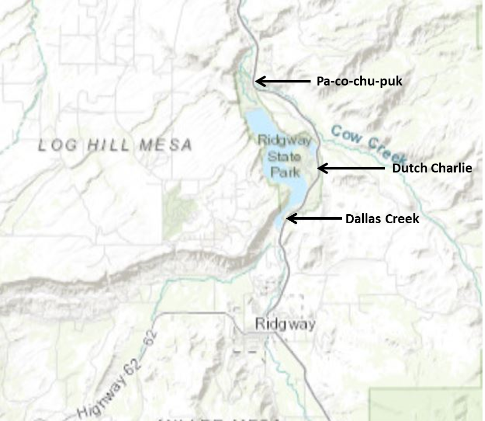
Ridgway State Park, Ouray County
Managed by: Colorado Parks and Wildlife / Bureau of Reclamation
Location: 2 miles north of Ridgway at Ridgway Reservoir
Ubicación: 3 kilómetros al norte de Ridgway, en el embalse de Ridgway
Directions: From Montrose, travel 17 miles south on US Highway 550 towards Ouray. The Park has three entrances, Pa-co-chu-puk on the northern end, Dutch Charlie in the middle, and Dallas Creek at the southern end. If this is your first visit, the Visitor Center is near the Dutch Charlie Entrance.
Indicaciones: Desde Montrose, recorra 27 kilómetros al sur por la US Hwy 550 hacia Ouray. El parque tiene tres entradas: Pa-co-chu-puk en el extremo norte, Dutch Charlie en el centro y Dallas Creek en el extremo sur. Si es su primera visita, el Centro de Visitantes se encuentra cerca de la entrada de Dutch Charlie.
Accessibility: An entrance fee (currently $9) is collected year-round. Either pay at entrance station or purchase or possess a current Colorado State Parks Pass. The parking lots are paved and public toilets are available.
Accesibilidad: Se cobra una tarifa de entrada (actualmente $9) durante todo el año. Puede pagar en la estación de entrada o adquirir o tener un Pase de Parques Estatales de Colorado vigente. Los estacionamientos están pavimentados y hay baños públicos disponibles.
Habitat: Accessing the park via the Pa-co-chu-puk entrance allows you access to the Uncompahgre River below the dam. In addition to several campgrounds (both RV and walk-in tenting) there is nice riparian habitat, several fishing ponds, rocky cliffs, a small Ponderosa Pine stand, mixed sagebrush savannah and pinon-juniper woodlands.
The Dutch Charlie entrance starts in a mix of dry sagebrush grassland and mature pinon-juniper woodlands. A lookout near the visitor center offers a sweeping view of the reservoir and the beautiful San Juan Mountains to the south. This section of the park also includes a boat marina and a small but good mud flat (at lower water levels) at the upper end of Mears Bay.
The Dallas Creek section includes sagebrush flats, pinyon-juniper-covered hillsides with exposed cliffs and good riparian habitat at the southern end of the park. It also includes a large section of exposed lakeshore at the Bay View Day Use Area as the reservoir water levels drop in late summer.
Hábitat: Acceder al parque por la entrada Pa-co-chu-puk permite acceder al río Uncompahgre, debajo de la presa. Además de varias zonas de acampada (tanto para autocaravanas como para tiendas de campaña), cuenta con un agradable hábitat ribereño, varios estanques de pesca, acantilados rocosos, un pequeño bosque de pino ponderosa, sabana mixta de artemisa y bosques de pino piñonero y enebro.
La entrada de Dutch Charlie comienza en una mezcla de pastizales secos de artemisa y bosques maduros de pino piñonero y enebro. Un mirador cerca del centro de visitantes ofrece una vista panorámica del embalse y las hermosas montañas de San Juan al sur. Esta sección del parque también incluye un puerto deportivo y una pequeña pero buena zona de lodo (con niveles de agua más bajos) en el extremo superior de la bahía de Mears.
La sección de Dallas Creek incluye zonas de artemisa, laderas cubiertas de pino piñonero y enebro con acantilados expuestos y un buen hábitat ribereño en el extremo sur del parque. También incluye una gran sección de orilla del lago expuesta en el área de uso diurno Bay View, ya que los niveles de agua del embalse bajan a fines del verano.
Birds you might see: Due to the variety of habitats and the large size of the reservoir, Ridgway State Park is the premier birding spot in Ouray County currently having a total of 235+ species recorded in global eBird database. The family corvidae is well represented (common raven, American crow, Steller’s jay, pinyon jay, Clark’s nutcrackers, black-billed Magpies, and occasional Canada Jays), as are raptors and ducks along with other water birds.
The Pa-co-chu-puk section is good for songbirds including a variety of warblers (yellow, Wilson’s yellow-rumped, Virginia’s, black-throated gray, MacGillivray’s), raptors (osprey, red-tailed hawk, bald and golden eagles), corvids, woodpeckers, and thrushes (American robin, Townsend’s solitaires, hermit thrush, mountain and western bluebirds).
The Dutch Charlie section is good for pinyon-juniper birds including all of the corvids listed earlier, plumbeous vireos, bluebirds, finches and goldfinches, sparrows (chipping, vesper, Brewer’s), and bluebirds. Near the reservoir ducks, grebes, shorebirds and gulls are commonly seen. Don’t forget to check out the reservoir from the overlook near the visitor center, especially if you have a spotting scope.
The Dallas Creek entrance provides access to the southern end of the lake where the Uncompahgre River enters the reservoir. The Bay View Day Use area is the point where you can access the exposed shoreline of the lake. This area is the best location for viewing the ducks, grebes, loons, gulls, and shorebirds that visit the reservoir in the spring and fall. Over 155 species have been recorded here. Moving further south in the park, Dallas Creek Day Use Area has a very nice riparian area, particularly along Dallas Creek upstream from where it joins the river. Yellow warblers, gray catbirds, house wrens, and song sparrows are common summer breeders. A banding station is set up here each fall, and it has produced some surprising finds including golden-winged warbler, hooded warbler, and yellow-breasted chat. Raptors such as northern pygmy-owl, golden and bald eagles, osprey, Cooper’s hawk, red-tailed hawk, American kestrel, and peregrine falcon are regularly seen in the area.
Aves que podrías ver: Debido a la variedad de hábitats y al gran tamaño del embalse, el Parque Estatal Ridgway es el principal lugar de observación de aves en el condado de Ouray, con más de 235 especies registradas en la base de datos global de eBird. La familia de los córvidos está bien representada (cuervo común, cuervo americano, arrendajo de Steller, arrendajo piñonero, cascanueces de Clark, urracas de pico negro y, ocasionalmente, arrendajos canadienses), al igual que las rapaces y los patos, junto con otras aves acuáticas.
La sección Pa-co-chu-puk es ideal para observar aves cantoras, incluyendo una variedad de reinitas (currucas amarillas, reinitas de rabadilla amarilla de Wilson, reinitas de Virginia, reinitas de garganta negra y reinitas de MacGillivray), rapaces (águila pescadora, gavilán colirrojo, águilas calvas y águilas reales), córvidos, pájaros carpinteros y zorzales (petirrojo americano, solitarios de Townsend, zorzal ermitaño, azulejos de montaña y azulejos occidentales). La sección Dutch Charlie es ideal para observar aves piñoneras y enebros, incluyendo todos los córvidos mencionados anteriormente, vireos plomizos, azulejos azules, pinzones y jilgueros, gorriones (gorjeo, vespertino, de Brewer) y azulejos azules. Cerca del embalse es común observar patos, zampullines, aves playeras y gaviotas. No olvide visitar el embalse desde el mirador cercano al centro de visitantes, especialmente si tiene un telescopio.
La entrada del arroyo Dallas da acceso al extremo sur del lago, donde el río Uncompahgre desemboca en el embalse. El área de uso diurno Bay View es el punto de acceso a la orilla expuesta del lago. Esta zona es el mejor lugar para observar patos, zampullines, colimbos, gaviotas y aves playeras que visitan el embalse en primavera y otoño. Se han registrado más de 155 especies. Más al sur del parque, el área de uso diurno del arroyo Dallas cuenta con una hermosa zona ribereña, especialmente a lo largo del arroyo Dallas aguas arriba, desde su desembocadura en el río. Las reinitas amarillas, los zorzales cenicientos, los cucaracheros comunes y los gorriones cantores son especies reproductoras comunes en verano. Cada otoño se instala aquí una estación de anillamiento, que ha producido algunos hallazgos sorprendentes, como la reinita alidorada, la reinita encapuchada y la curruca pechirrosa. En la zona se avistan regularmente aves rapaces como el búho pigmeo norteño, las águilas reales y calvas, el águila pescadora, el gavilán de Cooper, el gavilán de cola roja, el cernícalo americano y el halcón peregrino.
Best time of the year: Birding is best during migration, but birds are present year-round. Recreational use of the reservoir is quite heavy in the summer, so focus on the areas with less disturbance and try to arrive early or late in the day.
Mejor época del año: La observación de aves es óptima durante la migración, pero hay aves presentes todo el año. El uso recreativo del embalse es bastante intenso en verano, así que concéntrese en las zonas con menos perturbaciones e intente llegar temprano o tarde.
Additional information: http://cpw.state.co.us/placestogo/parks/Ridgway
eBird Hotspots:
Entire Park
Ridgway Reservoir & SP, Ouray, US-CO
Paco-chu-puk Entrance:
Ridgway Reservoir--below the dam, Ouray, US-CO
Dutch Charlie Entrance:
Ridgway SP--Visitor Center & campgrounds, Ouray, US-CO
Ridgway SP--Marina area, Ouray, US-CO
Dallas Creek Entrance:
Ridgway SP--Bay View Day Use Area, Ouray, US-CO
Ridgway SP--Dallas Creek area, Ouray, US-CO
Great Blue Heron or Sandhill Crane?

Information and photographs provided by Carole Scott